|
|
 19 aerial DHJanzen100787.jpg high resolution
|
|
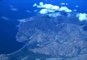
| This seemingly innocent aerial view of the Santa Elena Peninsula (central ACG) illustrates what is in image DHJanzen100785.jpg and DHJanzen100786.jpg above. The light-colored hills are the grass-covered hills in DHJanzen100786.jpg. The annual fires sweep (swept) downwind from the lower right toward the center of the photograph (a generally westerly direction). At the top center is unburned dark green-gray dry season forest as in image DHJanzen100785.jpg above. And, there is a sharp line between these two vegetation types. Each year of fire, the grasses advance a bit more into the forested part of the Peninsula, and with another 100 years of this treatment, the peninsula would have been Trachypogon grass all the way to its tip. It has taken several centuries to burn this thoroughly, and below the photograph is 20 km of fire-generated serpentine grasslands (upwind). The more moist (and better soil) bottomlands with their remaining forest fragments are very evident. In the lower left is evergreen mangrove forest growing on saline and freshwater swamp soils that never become dry enough to burn. On the point in the upper left is a pale green freshwater marsh untouched by cattle or fire. | ||
back to lecture slides
or skip to: